XC Track – Tips and Tricks Part II
XC Track can be used to maximise XC points in flight. In addition to flying skills, this requires detailed knowledge of how XC Track is displayed and how it works.
XC Track can be used to maximise XC points in flight. In addition to flying skills, this requires detailed knowledge of how XC Track is displayed and how it works.
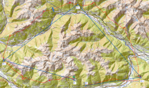
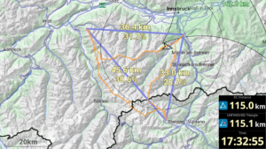
Every user of portals such as DHV-XC or XContest is familiar with the XC points displayed there. For the classic home mountain pilot, the points may not really matter, but for the ambitious pilot and points hunter who might want to win a competition, the theory behind them should be known. Especially as there are a few tricks and tips to maximise your points and increase your chances in the competition.

I already explained in an article three years ago that overhead power lines harbour particular dangers for us paraglider pilots. In this article, I would like to go into detail about the construction and route of overhead power lines so that you are able to recognise them from the air and include them in your planning before the flight.
Who among us has not yet had an encounter of the first kind (visual contact) with our flying colleagues, the glider pilots? In order to avoid an encounter of the second kind (physical contact), we should all adhere to the pre-flight rules. Achim Holzmann has explained this and other things clearly in a much-noticed video.

Most of us know the IGC file (en: International Gliding Commission) as a file that a vario creates, in which the flight path is recorded and which can be uploaded to one of the Internet portals, such as the DHV-XC or XContest, after the flight. When opening the file with a normal text editor, you can recognise some information in plain text, but most of the data is very cryptic. However, it is worth taking a closer look at what is hidden behind it in order to better understand the background to airspace violations, for example.
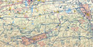
What do I have to bear in mind from an aviation law perspective if I want to fly from A to B? What sources, preferably first-hand, are available to me for this? How can I carry out my planning from a very pragmatic point of view? Oliver Thomä provides answers to these questions in a seminar without too much "ballast".