What do I have to bear in mind from an aviation law perspective if I want to fly from A to B? What sources, preferably first-hand, are available to me for this? How can I carry out my planning from a very pragmatic point of view? Oliver Thomä provides answers to these questions in a seminar without too much “ballast”.
Introduction
The topic is aviation law without ballast, although the “without” is an exaggeration, as aviation law cannot be taught entirely without theory. However, there is no need to make things more complicated than absolutely necessary. For example, we often talk about visual flight conditions, but these are not relevant to us in detail. The seminar tries to minimise the effort and is intended for pilots who perhaps want to fly 50 to 100 km.
Goals
The following points were defined as objectives for the seminar:
- The seminar offers help for self-help
- Practical implementation of aviation law
- Practical flight planning without (too much) ballast
- The seminar is aimed at XC beginners and advanced riders
- The airspaces over Germany, Austria & Italy are examined in more detail in the seminar.
Not targets
The following points are not the objectives of this presentation:
- Complete seminar on aviation law
- Laws, ordinances, administrative regulations, Nachrichten für Luftfahrer, other documents
- XC pro who wants to squeeze out the last XC kilometres
- All “prohibited” airspaces, a precise definition of these airspaces will follow later
- Flying with aeronautical radio. Very few pilots fly with aeronautical radio and it is usually not necessary for the normal pilot either.
Disclaimer
- The pilot is responsible for carrying out the aeronautical briefing
- The following statements are not legally binding
- The pilot is responsible for compliance with all legal provisions
- The pilot is responsible for compliance with the airspace and visual flight conditions
Sources, contacts
Unfortunately, it is often common for paragliders to obtain information from secondary sources, but nowadays there are many first-hand sources that are freely available on the Internet. First and foremost are the homepages of the air traffic control centres:
- German air traffic control
- Austro Control Homebriefing
- Società Nazionale per l’Assistenza al Volo (ENAV)
The homepage of Austro Control and ENAV will be discussed in detail later. Other sources of information that should be mentioned (all the following sources are not legally binding):
- German Hang Gliding Association
- Hans Lang, Facebook group Flugrecht für Gleitschirmflieger, if you are a Facebook member, you can ask questions about air law there
- The homepages of the clubs often also provide information on the subject of aviation law
- It doesn’t hurt to ask a local hero if you’re on take-off in case you don’t understand the airspace structure.
- Ad Nubes, keyword air law, my blog with some articles about air law
- Flying in Italy (in german) is actually intended for motorised pilots, but nevertheless provides a good overview of the airspace structure in Italy.
Aviation manuals
The Aeronautical Information Publication (AIP) is often not used as a source, but it offers a lot of important legally binding information. In my blog you can find an evaluation for us paraglider pilots, Austro Control, which offers a very comprehensive AIP, deserves special mention.
The following parts of the AIP are particularly relevant for us paragliders, using Austro Control as an example:
- GEN 2.2, the abbreviations commonly used in aviation. As abbreviations are used extensively in the AIP, sometimes even making them illegible, it is essential to memorise at least the most important abbreviations
- GEN 2.3, the chart symbols used in the ICAO charts. To read the ICAO charts, it is essential to familiarise yourself with the symbols used in them
- GEN 3.1, information on AIP amendments (AMDT), AIP supplements (SUP), NOTAMs (Notice to Airmen) and aeronautical information circulars. The NOTAMs, which should be checked before every flight, should be emphasised
- GEN 3.2, information on the aeronautical chart, which can be downloaded free of charge from the Austro Control website
- ENR 1.2, minimum flight altitudes, flights with hang gliders and paragliders, special avoidance rules. Should be read through every now and then to refresh your memory
- ENR 1.4, explanations of airspace classes, visual flight minima, available services. Airspace classes is another thing I always have to remind myself of. Since air law is neglected during training, this is a good source for expanding your knowledge
- ENR 5.5, Temporary Civil Airspace Reservation (abbreviation TRA). Class C or D airspaces are temporarily cleared for us. The clearances can be intercepted via ATIS, for example.
The AIP can be accessed after logging in to Austro Control Homebriefing in the menu under AIP.
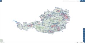
Airspaces
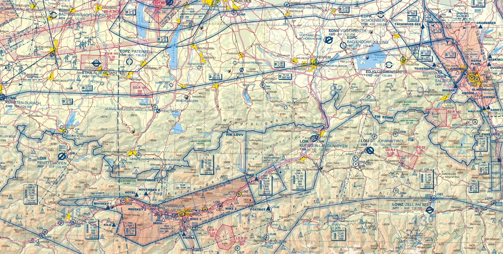
The following illustration can be downloaded from Austro Control and provides a good overview of the airspace structure:
As we said at the beginning, to make our lives as easy as possible, certain airspaces should be avoided:
- Basically all airspaces whose status is unknown or airspaces that are unknown to us
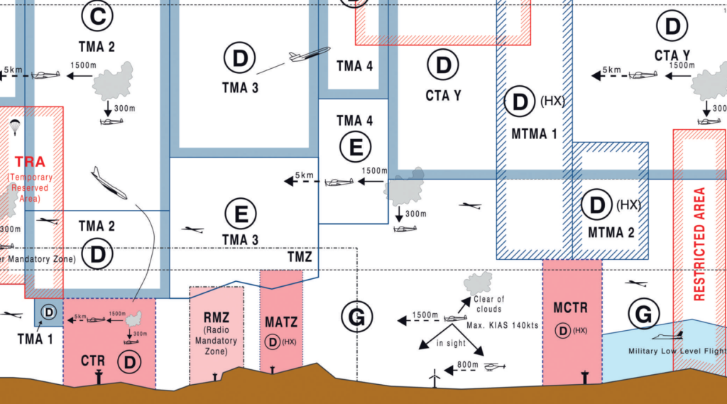
- We are generally not allowed to fly into airspaces C & D
- In some airspaces with the designation Restricted (..-R) you may be allowed to fly in, but you must then check the Aeronautical Information Publication or NOTAMs to find out under what conditions and whether this is active
- Flying into Danger airspace (..-D) is permitted, but not recommended
- Flying into the airspace Prohebited (..-P) is generally not permitted
- Airspaces with the identifier ..-HX are active for a limited time. The times are noted in the AIP
- Airspaces with the following designations are generally taboo: TMA, (M)CTR, TMZ, RMZ, (M)ATZ …
- Newbies should not fly into Temporary Reserved Airspace (TRA)
Our playgrounds, where we are allowed to move freely, are:
- In Germany & Austria: Airspaces G and E
- In Italy: Airspace G, there is also airspace A around Milan, where we are allowed to fly, but this is not relevant for us
- Airspace E extends to flight level FL100 in the German lowlands and to FL130 in the Alps; airspace E is lowered around airports in particular
- In the Austrian Alps up to FL125
- In Italy, airspace G goes up to FL85 to FL145, depending on the region.
Tips:
- Maintain a large vertical safety distance from prohibited airspace, as large commercial aircraft are guided right up to the lower airspace boundary and generate strong wake vortices. It is recommended to keep a distance of at least 500 ft. In strong thermals, it is still possible to be drawn into a prohibited airspace
- As Georg explained in his article, it is advisable to fly according to GPS altitude in high-pressure conditions, as the lower flight level airspace limits move upwards. Normally, it should be ensured that these limits are adhered to. This statement does not apply to limits given in feet
- Flying areas with a simple airspace structure should be favoured, for example South Tyrol, Pinzgau, Kössen, as in these areas you don’t have to deal with airspaces as intensively.
Height measurement
The altitudes of the airspaces are specified in feet, so it is advisable to also measure the altitude in feet and optionally in metres, as this is what we are used to.
In aviation, altitude measurement is still dependent on air pressure.
Tips:
- If GPS altitude display is available, then fly according to it
- Safe distance to flight level xyz when flying with GPS altitude, as flying is usually done at high pressure
- Altitude information in flight levels shifts upwards at high pressure
- Additional distance of 1000 ft recommended due to visual flight conditions and wake vortices
Visual flight conditions
The problem is that the visual flight conditions are not practicable because:
- the vertical distance between clouds cannot be estimated visually
- the visibility in flight direction is hardly assessable
- To make matters worse, there are different regulations inPolylangplaceholder do not modify
Tips:
- Always fly to the best of your knowledge and belief, keeping your distance from the clouds
- Take particular care when flying at high altitudes and in the vicinity of aerodromes and airports, as increased air traffic is to be expected there
- If possible, fly on days with a high base, recommended in the lowlands at least 2000 m MSL, and in the mountains at least 3000 m MSL
The following video shows a good example of how quickly you can be drawn into the cloud:
Flight from the Wank to the Bischling
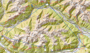
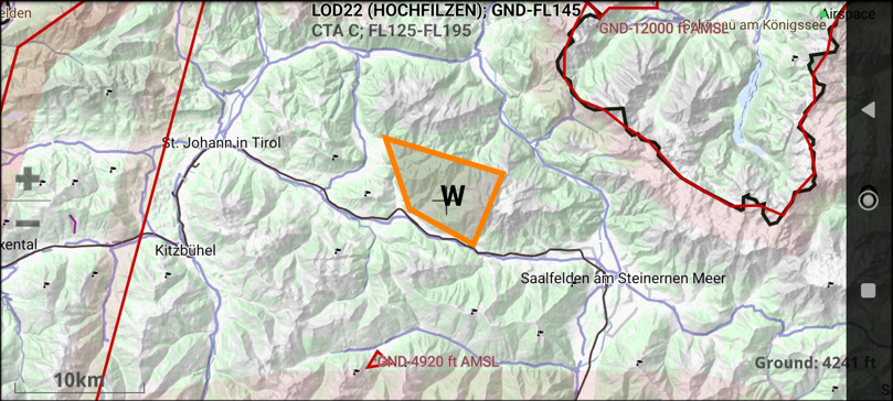
The flight from Wank to Bischling over the Karwendel Mountains, the Rofan Mountains and the Hohe Salve was set as the task for the air traffic planning, see also the green line in the ICAO map of Austro Control.
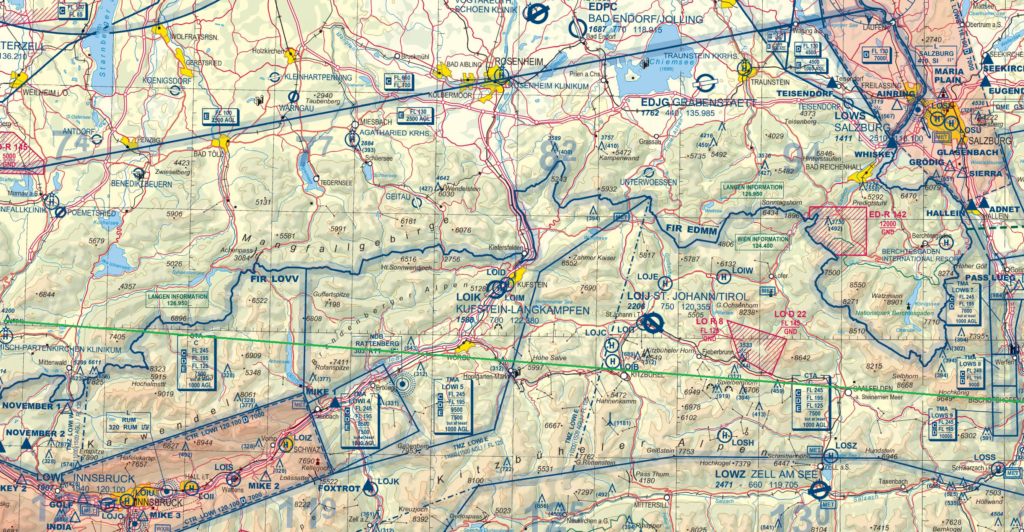
The ICAO chart can be downloaded free of charge from Austro Control at: www.homebriefing.com Links -> Österreichische AIM Produkte -> Luftfahrtkarte – ICAO 1 : 500 000. In principle, when planning a flight, you should first use the official legally binding sources and then, to be on the safe side, use 2nd or 3rd hand sources.
After analysing the airspaces, the following should be noted:
- Take-off on the Wank, here airspace E, which goes up to FL130, must be observed
- From Austria, airspace E goes up to FL125, and there is also a TMZ (Transponder Mandatory Zone) from 11000 ft into which we are not allowed to fly. The TMZ is therefore decisive for the maximum permitted altitude here
- Over the Rofan mountains, airspace E extends up to 9500 ft
- Above the Hohe Salve again airspace E up to FL125 and the TMZ from 11000 ft
- Over Kitzbühel Airspace E to FL125
- My recommendation is to fly around LO R 8, LO D 22, then you don’t have to worry about the details
- In the area around Werfen, there is a lowering of airspace E to 10000 ft, up to 9000 ft or up to 7000 ft, which results from the approach and departure routes of Salzburg Airport. We would like to emphasise once again that the distance to the clouds must be maintained.
Interactive online map VFR
As mentioned above, it is advisable to confirm the findings from the ICAO chart using a second source. The second source can be the interactive online VFR chart provided free of charge by Austro Control.
I have described the online map in detail here.
For other countries, alternatives available in Burnair are the airspace finger (subject to a charge) or XContest Airspace.
NOTAMs
Conscientious planning also includes checking the NOTAMs (Notice to Airmen), which list the current restrictions.

I have described in this article how to call up the NOTAMs at Austro Control.
This booklet (in german) from German air traffic control contains information on the NOTAMs, such as the abbreviations used.
Problem: Due to external conditions (different wind strength, direction, weaker thermals compared to the forecast) at the launch site or in the air, changes to the flight route can occur at short notice.
Solution: The NOTAMs are displayed in XC Track. The source for this is XContest Airspace. Before the flight, you should check whether the airspaces and NOTAMs have been updated.
Flight on Mount Grappa
The second task was a flat triangular flight on Mounte Grappa. The start is at Bepi, heading east until shortly before the river Piave, heading west until shortly before the river Astico and back again towards Bassano. To make it a flat triangle, a short detour into the lowlands is necessary (see green line on the ICAO map).
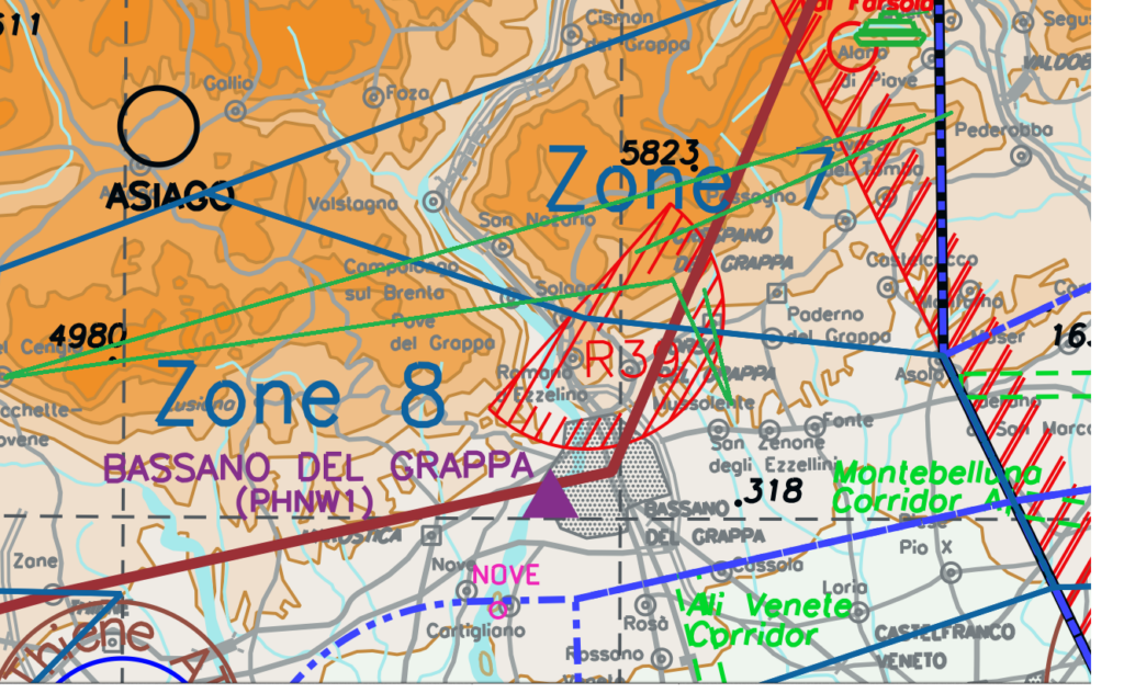
I have described the flight and where to get the necessary information in the article The airspaces in Bassano del Grappa and surroundings.
XContest Airspace
The website XContest Airspace can be used as a second source to confirm the above findings.
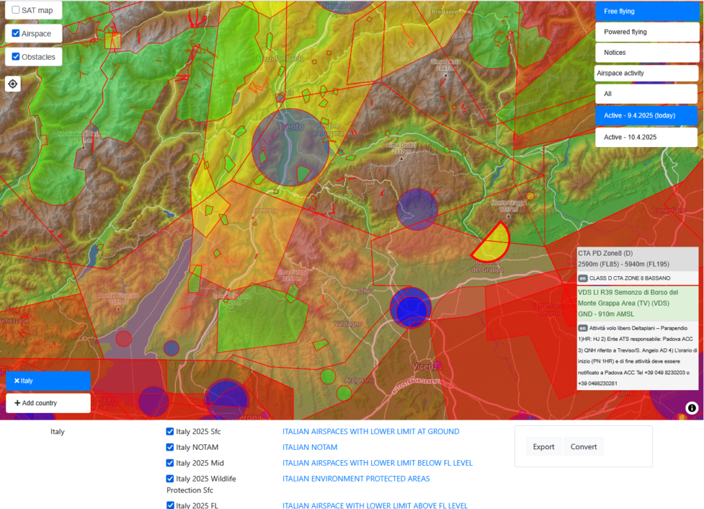
In the online map, activate the desired country at the bottom left, in our case Italy, and tick the Airspace box at the top left. Click on a specific point to display details of the airspaces at the bottom right. Under Settings you can change the altitude in metres.
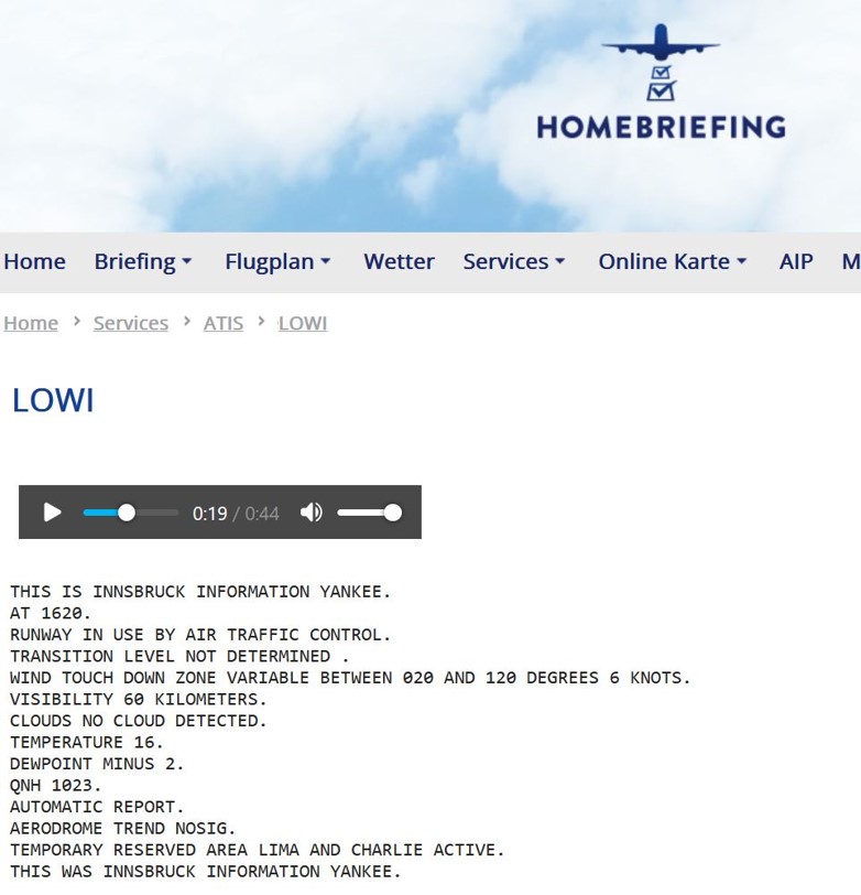
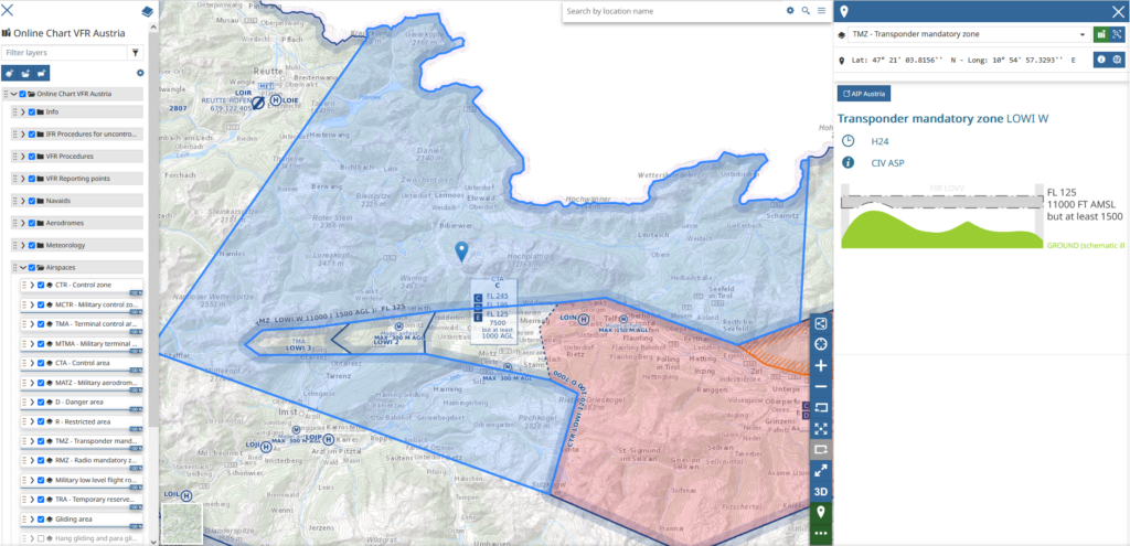
Innsbruck airspace
In order to fly the Karwendel Dreieck from Brauneck, the TRA LOWI C on the Nordkette must be active. The TRA can be displayed in the interactive online map:
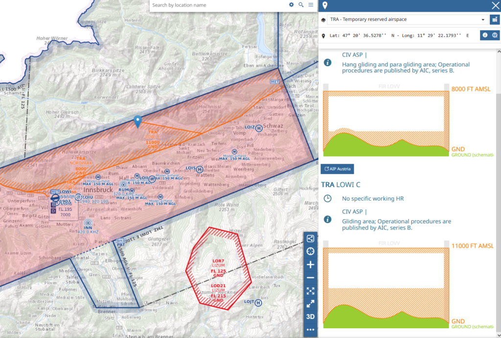
Further information on the TRAs and the airspaces and how to behave can be found on the website of the Innsbruck Paragliding Association (in german). The official information from Austro Control is available here.
The ATIS (Automatic Terminal Information Service) of Innsbruck Airport with information on whether TRA LOWI C is active can be called up at the following telephone number: +43 5 1703 6631
This is what an ATIS announcement sounds like (note, this is only an example, of course the ATIS can be called up on a daily basis):
The ATIS is also available in written form on the Austro Control home briefing page (note that this is also only an example):