
With ThermiXC, Bernd Gassner has provided us paragliders with an excellent tool to plan longer distances. How I want to increase my efficiency in cross-country flying with the help of this website in combination with other sources such as books, YouTube videos, magazines, blogs, etc., I explain in this post.
Principles
The basic structure of the flight plans is very much schematized and standardized. This should help to facilitate flight planning and to find the information one is looking for as quickly as possible. The flight plan I have filled out can be downloaded as an Excel file from the corresponding article and can be adapted and extended according to your own requirements. Every interested pilot is encouraged to send me corrections and extensions to the flight plans.
Below you can download a bare template as Excel file and use it for your own flight planning.
Limitations
The explanations and flight plans that I provide free of charge in this blog are subject to the following restrictions:
- The pilot must independently inquire about the meteorological conditions on the day of flight
- The airspaces, other restrictions as well as the daily updated NOTAMs are to be checked
- Danger areas and emergency landing sites must be checked
- You have to decide on your own if your skills are sufficient for the planned flight.
- The information in the flight plan is based on my skills. Information e.g. about emergency landing sites may not be suitable for the beginner, while the professional landing will only bring a tired smile
- I will only update the flight plans when a planned flight is imminent. Conditions on the planned route may change over time
- I am only a below average cross country pilot myself, so my plans are bound to be flawed and incomplete. Therefore, of course, I cannot give any guarantees for the correctness of the flight plans
- Furthermore, I have thought up the flight plan only theoretically based on literature, YouTube videos, forum posts etc., whether the flight plan will prove itself in practice will (hopefully) become clear this year
Tools
The following is a list of the tools I use to fill out the flight plan. Excluded from this are the tools I use for weather forecasting, which I will not present here.
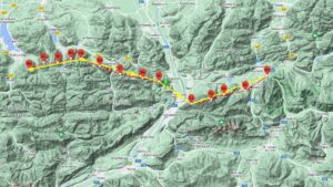
ThermiXC
ThermiXC is probably the most important tool to perform flight planning. To get with good probability thermal connection, I set the waypoints as they are shown to me with “kk7 Thermals” and “kk7 Hotspots”. To find a good route, I temporarily turn on “kk7 Skyways all time&date”.
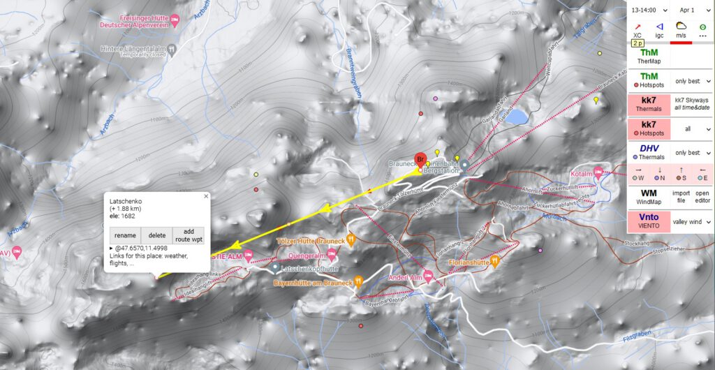
To find the distance between waypoints, the first waypoint is to be clicked, now a blue flag should appear (often obscuring the red waypoint flag). Then click on the second waypoint, the distance is shown in brackets, in this case 1880 m. Further, the altitude above MSL of the waypoint can be read directly.
OpenTopoMap
Unfortunately, the ThermiXC map does not list all the names of the mountains (ThermiXC is based on Google Maps), so I use OpenTopoMap, to sensibly name the waypoints after the names of the mountains (where available).
DFS, Austro Control, ENAV and OpenAIP
Since I mostly fly in Germany, Austria or Italy, I use their websites of the respective air navigation service providers DFS, Austro Control, ENAV and OpenAIP to find out about airspaces, restrictions, NOTAMs, regulations and air radio frequencies and to do a homebriefing.
Viento valley wind
Since the latest version of ThermiXC it is also possible to display the valley wind systems. This requires a subscription to Viento. I use the display to identify soaring edges that could ensure one’s survival in the air. Furthermore, danger spots due to lee traps or difficult sections (which could possibly be avoided) can be identified by strong valley wind systems.
Google Earth
I use Google Earth to find and identify emergency landing areas, restrictions and hazards on the planned route.
DHV-XC, XContest
I use the online contest platforms DHV-XC and XContest to analyze other flights and evaluate pilot comments and possibly incorporate them into my own flight planning.
The flight plan as Excel-sheet
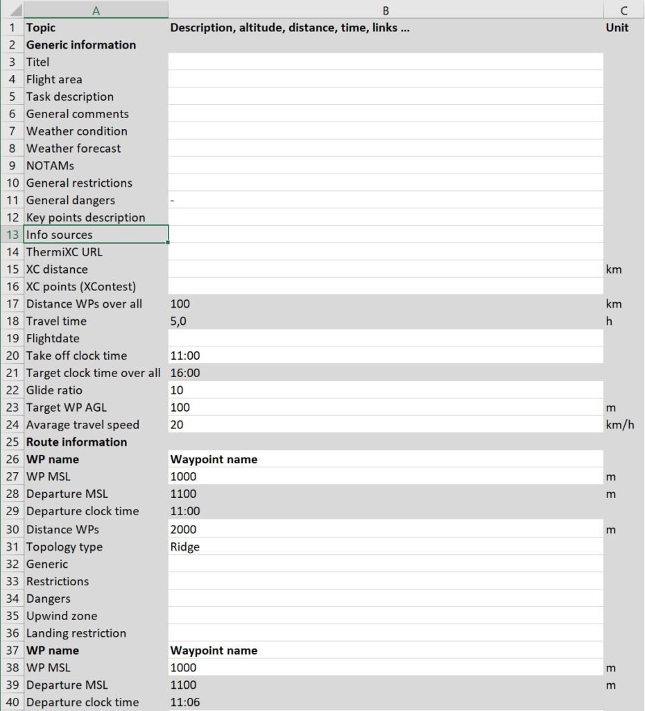
The flight plan is divided into the “Generic information” and “Route information” sections. The “Route information” section is in turn divided into 50 flight segments, each of which is delimited by the start waypoint and the destination waypoint. The meaning of the individual lines is explained below.
The cells with white background are meant to be filled in, the ones with gray background should not be changed. But nothing is locked in the Excel list, so it can be extended, changed and deleted at will.
Generic information
This section contains general information about the flight plan.
Titel
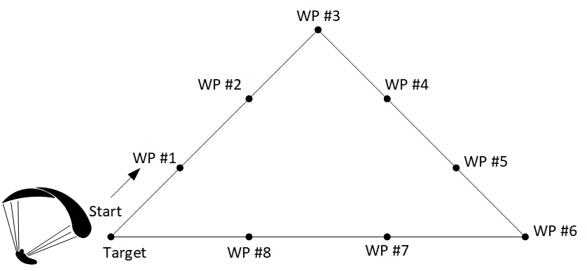
Titel of the task, e.g. “The Karwendel Triangle”.
Flight area
Brief description of the area for which the flight plan is valid.
Task description
General brief description of the planned route.
General comments
General comments, e.g. which month is best suited for the task set.
Weather condition
Weather conditions suitable for performing the task, e.g. base altitude required, favorable wind direction and strength.
Weather forecast
A brief description of the major weather situation, frontal passages, weather in the last few days, etc.. Thermal start and end, thermal strength, cloud base during the day. Wind strength and direction on the planned route.
The information can of course only be filled in on and shortly before the planned flight day.
NOTAMs
A brief daily summary of the NOTAMs published by the respective air traffic control authorities of the countries in which the intended flight route leads.
General restrictions
General restrictions imposed by airspaces and their source information, as well as information on events or anything else that might impede flight.
General dangers
Known dangerous areas on the flight path.
Key points description
Key locations on the planned flight path, such as long valley crossings, wind systems, etc.
Info sources
Sources that was available for flight planning such as books, YouTube videos, magazines, blogs, forums, planning tools, etc.
ThermiXC URL
The short URL generated from ThermiXC. The waypoints and route can of course be adapted to your own wishes and ideas. For each waypoint the first two letters of the name are displayed. From ThermiXC the waypoints and route can be downloaded depending on the used vario.
XC distance
The XC distance displayed in ThermiXC after planning the route according to FAI rules.
XC points (XContest)
The XC points displayed in ThermiXC depending on the FAI task (triangle, flat triangle, etc.).
Distance WPs over all
Summation of all distances of the individual flight stages, determined from the distances of the waypoints (“Distance WPs” line) in the “Route information” area.
Travel time
Calculated travel time calculated from “Distance WPs over all” divided by “Avarage travel speed”.
Flightdate
Date of the planned flight day.
Take off clock time
Time of the planned takeoff, should not be before the expected start of thermals.
Target clock time over all
Calculated arrival clock time, calculated from the take-off clock time plus travel time, should be before the expected end of the thermal.
Glide ratio
Glide ratio of your glider plus the expected sink rate between thermals. If a lot of acceleration is flown, this must also be taken into account. For example, if your glider has a glide ratio of 1:9, a glide ratio of 8 or less should be specified here.
Target WP AGL
The desired altitude above the target waypoint over ground in meters. Should be selected high enough to allow sufficient time for thermal search.
Avarage travel speed
Planned average airspeed. For one-way flights, higher speeds can be used than for triangle flights. For the beginner cross-country pilot, FAI triangles may be around 15 km/h, for professionals who do a lot of accelerated flying, over 25 km/h. For one-way flights, a value of 30 km/h or above can be given if there is a lot of tailwind.
Route information
The individual sections of the route are stored in this area. In the template you will find 50 sections, which can of course be extended as desired. Please make sure that the stored formulas are still correct after the copying process.
WP name
Waypoint Name, this should match the waypoint name selected in ThermiXC.
WP MSL
Height of the waypoint above ground. This value can be read from ThermiXC, see explanations above.
Departure MSL
Calculated departure altitude MSL.
Calculation if you select topology type “Valley”: Distance WPs divided by glide ratio plus altitude next WP MSL plus WP destination WP AGL.
Calculation if you select something else: Altitude next WP MSL plus WP destination WP AGL.
For tactical reasons, it may of course make sense to aim for a significantly higher departure altitude. The result of the calculation only tells you that you would reach the destination waypoint at a certain altitude with the given parameters.
Departure clock time
To have an approximate idea of the time management in flight, this value is calculated from the previous time plus distance of waypoints divided by the average cruise speed.
Distance WPs
Distance as the crow flies from the previous waypoint to the next waypoint. The distance can be measured using ThermiXC, see explanations above.
Topology type
Topology type “Valley”, “Ridge”, “Flat” or “Void” is used to calculate the Departure MSL. Select “Valley” if there is a valley between the waypoints and select “Ridge” or “Flat” if you are flying along a mountain range or in the flat.
Generic
General notes on this flight segment between the two waypoints.
Restrictions
Restrictions due to airspace, restricted areas, nature reserves, airfields, etc. between the two waypoints.
Dangers
Hazards due to wind, lee areas, valley winds, cable cars, etc. between the two waypoints.
Upwind zone
Known thermal points and upwind areas.
Landing restriction
Information on landing restrictions due to forests, buildings, rivers and other unlandable areas, as well as official landing sites or emergency landing sites such as meadows, parking lots and other open areas large enough to land with a paraglider.
Update: Add alternative waypoints

Pingback: Flightplan Wallberg to Koessen – Ad Nubes – To the clouds
Pingback: Flightplan Karwendel FAI Triangle – Ad Nubes – To the clouds
Pingback: Flightplan Moellvalley Triangle - Ad Nubes | Paragliding blog