Bassano is well known among paragliders, but what is less well known is what the airspace structure around Bassano looks like. Up to now I have hardly paid any attention to the airspace structure, but have flown as close to the slope as possible and not too far into the flat. However, I would like to change this and take a closer look at the airspace structure.
Introduction
More and more air traffic control authorities are making the Aeronautical Information Publication (AIP) available online free of charge, including ENAV, the Italian air navigation service provider. The AIP can be accessed via the Services menu and the AIP Request Access link after free registration and login with ENAV. It is annoying that the website keeps switching to Italian. You have no choice but to keep switching to English at the top of the menu. By clicking on Access to eAIP-Italy further down and in the Effective date table, you can finally access the AIP. In chapter 6.3 VFR area charts, you can open the ICAO map divided into different areas of Italy in PDF format. For Bassano and surroundings, the map Padova VFR Area is required.
It is a mystery to me why ENAV has chosen a fundamentally different presentation compared to other ICAO charts. In other ICAO charts, it is common practice to write the vertical airspace boundaries directly on the horizontal boundaries of the airspaces. In the Italian ICAO chart, references are used, e.g. the airspaces D are numbered consecutively on the chart and the vertical boundaries are defined at the top left of the chart. This makes reading, especially on a computer, unnecessarily cumbersome.
Limitations
The consideration of the airspaces in this article is subject to the following limitations:
- Although I have taken the greatest possible care in compiling this article, errors and misinterpretations on my part cannot be ruled out
- In any case, I am not an expert in air law, therefore it is the responsibility of each pilot to carry out a comprehensive briefing in accordance with the legal regulations on their own responsibility
- This article was created with the help of the AIP valid at that time. The AIP is regularly updated by ENAV, therefore the current status of the AIP must be consulted for the personal briefing
- The usual abbreviations in aviation and what a flight level is should be familiar to the interested reader, an explanation is not provided in this article
- Unfortunately, the international regulations of the ICAO are transposed into national law with deviations, including in Italy. I cannot go into this in detail in this article, but I recommend that interested readers visit the website Flying in Italy (only in german)
Airsspace
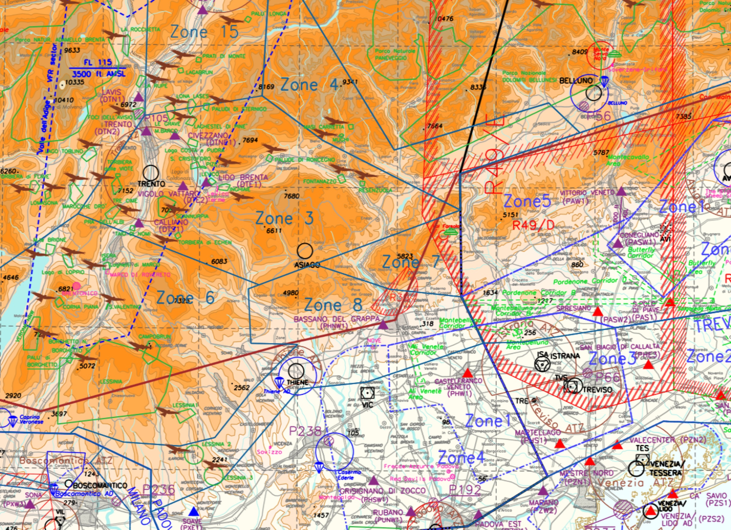
The consideration of the airspaces is limited to approximately west of the river Astico in the west to the river Piave in the east. This corresponds approximately to the XC route of 100 km, which is often flown when starting from Bassano and returning there. If you want to fly further, you should study the corresponding areas further west and east on the ICAO map.
Airspace D
The airspaces D are labeled and numbered with zone, the borders are framed with dark blue lines. Only the lower boundary of interest to us is shown below:
Zone 5: lower boundary FL 145
Zone 6: lower boundary FL 105
Zone 7: lower boundary FL 85
Zone 8: lower limit FL 85
In Bassano the base is usually rather low, but flight level 85, corresponding to about 2590 m depending on the air pressure conditions, could already be reached. Zone 7 lies between the Astico and Brenta rivers and zone 8 between the Brenta and Piave rivers, i.e. in the area where we are flying as cross-country pilots for the route mentioned above.
Restricted Areas
Part ENR 5.1.2 contains explanations of the restricted areas:
R39: An area reserved for us paraglider pilots, but which must be activated at the Padova ACC. Perhaps useful for flying schools, but less interesting for cross-country pilots. I do not know whether it will be activated. The airspace extends from GND to 3000 feet (approx. 914 m).
R49: Military activity is to be expected in the restricted flight area, but if you remain on the mountain range to the lowlands, the lower airspace limit is FL 130 and it is therefore rather unlikely that you will reach this altitude. Further south, the restricted flight area starts at FL 50 or 2000 feet AGL, an altitude that should not be exceeded.
Miscellaneous
There is another ATZ Thiene with a skydiving zone south of the river Astico, which should be noted.